
Source: Xinhuanet
07-18-2007 18:13
 |
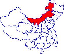 |
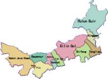
Brief Introduction: Situated on China's northern frontier, the Inner Mongolia Autonomous Region shares a 4,220 km borderline with Mongolia and Sibera. It covers an area of 1.183 million sq km inhabited by 22.32 million people of the Mongol, Han, Duar, Ewenki, Hui, Manchu and other ethnic groups. The regional capital is Hohhot, a railway hub in the central part of the autonomous region.
Climate: Inner Mongolia, with a temperate continental monsoon climate, has a cold, long winter with frequent blizzards and a warm, short summer. Except for the relatively humid Greater Hinggan Mountain area, the greater part of Inner Mongolia is, from west to east, arid, semi-arid and semi-humid.
Topography: Inner Mongolia forms the greater part of the Inner Mongolia Plateau, with the Greater Hinggan and Yinshan ranges stretching from northeast to southwest. It may be divided into six zones according to its terrain. 1) The northeastern part is made up of the Greater Hinggan range, with an elevation of 1,000-2,000 meters and dense forests. 2)The Hulun Buir Plateau west of the Greater Hinggan range, about 1,000 meters above sea level, has vast grasslands well suited for grazing. 3) The Northern Inner Mongolia Plateau, also 1,000 meters above sea level, comprises vast excellent natural pasturelands. There are many deserts on the plateau, especially in its west. 4) The Songliao Plain east of the Greater Hinggan range adjoins the Northeast Plain. 5) The Hetao Plain, Known as the "granary along the Great Wall", between the Yinshan Mountains and the Yellow River is crisscrossed by streams and fields. 6) The Ordos Plateau stands south of the Yellow River at a height of 1,200 meters.